
![]()
![]()
![]()
 by Marc Becker
January 11, 2007
Five years ago I made a road trip to Alaska. Over the course of 30 days, I traveled almost 10,000 miles to the Arctic Circle and back. One of the most memorable experiences was camping on the Arctic Circle at the June solstice sweating in a hot tent under the relentless midnight sun. Enormous mosquitos swarmed outside trying to get at my blood.
The scenery on that trip was stunningly beautiful. It also made me wonder whether the other end of the Americas was similar to what I had experienced up north.
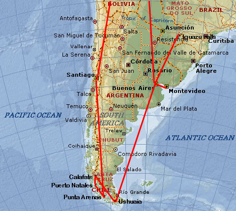
Thus began plans for a trip to southern South America. The plan was to fly from Madison through Chicago, Miami, and Santiago to Punta Arenas, Chile’s southern most city. From there I would travel by bus back north up through the spine of the Andean Mountains to Calafate on the Argentine side of the border. I would then fly back down to Ushuaia, considered the world’s most southern city on the island of Tierra del Fuego.
The December solstice seemed to be a good time for the trip, both because I thought the southern summer would provide a break from the onset of Madison’s cold winter and that the long days would provide an opportunity to enjoy the great outdoors as in Alaska. I was only partially correct on both counts.
After a very long travel day due to interminable flight delays, I arrived in Punta Arenas at midnight on December 15. It was dark, cold, and rainy. A taxi driver said that they were experiencing a virtual heat wave, that the temperature rarely rises about 15C. So much for escaping the northern winter. I should have brought my parka and gloves.
Most of the world’s land mass is in the northern hemisphere. Although I could drive to the Arctic Circle, it is not possible to make a similar overland voyage to the Antarctic Circle. In fact, even though the South American continent reaches further south than any other land mass other than Antarctica itself, on the 53 parallel I am only as far from the equator as Jasper in Alberta or Moscow in Europe. It makes for nice long days that helps with light deprivation, but even on the solstice by 11 pm it is already getting dark. Suddenly, it does not seem that I am that far south.
Patagonia’s climate is also significantly different than Alaska. The meeting of the Atlantic and Pacific oceans create cool and turbulent weather patterns. Summers never get hot, and on the other hand winter temperatures only drop down to around freezing. Alaska, on the other hand, has a continental weather pattern that leads to large temperature fluctuations.
 In Madison, solstice celebrations are alternatively mosquito-laden or toe-freezing affairs. In Patagonia, I did not encounter mosquitos, nor was I in danger of losing my toes to frostbite. Perhaps it is an OK compromise.
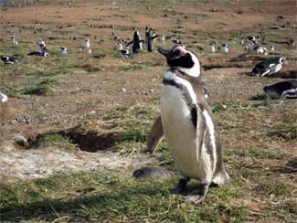
Punta Arenas is located on the Magellan Straits, with Tierra del Fuego and other outlying islands scattered to the south. I hopped on a ferry heading two hours north to Magadalena Island where a colony of 120,000 penguins live. I expected the ride to be cold, but sitting out on the deck on the sheltered side of the boat was quite comfortable. Two dolphins swam alongside the boat. As we approached the island, penguins swam out to join us.
Thousands of penguins nest on the island. With their fluffy gray youngsters, they waddle on the rocks by the beach, on the grass, in their burrows (who knew they burrowed like gophers?). They always appear that with one wrong step they will tumble over. They turn their heads back and forth, sort of like dogs do when they’re trying to listen. So, if you look one in the eye and tilt your head left and right, the penguin will swivel and twist its neck in the opposite direction until one of you gets tired.
 I then traveled south of Punta Arenas to Fuerte Bulnes. The road stops short of Cape Froward, the furthest south point on the South American mainland. I stare south across snow covered islands with the clouds reaching down to where I stand. Even though I am at sea level on the Magellan Straits, it seems as if I am at the top of the world. The view is stunning, but the landscape quite different from Alaska on this reverse-Arctic voyage.
Sitting on the rocks with my hair in a riotous tangle in the wind, I hear what sounds like a whale expelling air through its blow hole. Were it not for the sound, I would have missed it. A sea lion surfaces and dives, blowing out and taking in air. Once it comes up with a whole silver fish in its mouth.
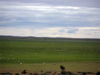 The original plan was to take a bus from Buenos Aires to Tierra del Fuego through the Argentine pampas. Reading through travel guides that describe an “endless expanse of nothingness” convinced me otherwise. Instead, I take short hops I travel north up the Andes. On the 3-hour trip north to Puerto Natales I stare out the window at endless expanses of grazing sheep until I gradually drift off into a netherworld.
Puerto Natales sits at the base of Ultima Esperanza Sound and is surrounded by stunning snow-covered peaks. The sun is warmer, but the wind whipping off the sound becomes uncomfortable and chases me back inside. Torres del Paine is about 100 kilometers farther north. It is Chile’s most beautiful national park, with snow-capped peaks, blue icebergs, and waterfalls. If this is reverse Alaska, I’ve started on the north slope and am now heading toward Denali.
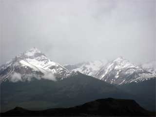 The weather is wet and drizzly, with the mountains mostly clouded in. Not the best conditions. I came back to the hotel wet, cold, tired. The park ranger said that this weather is normal. A guide book says that the park has no bad weather, just poorly prepared travelers. Moist air blows off the pacific coast and is trapped by the Andean ridge, which means that the eastern pampa is often windy but dry while the Andes are windy and cloudy and wet.
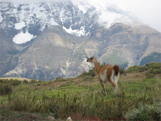 What I did see, though, were guanacos. Lots of them, quietly grazing alongside the road. (A guanaco is one of four members of the Andean cameloid family--the others being the llama, alpaca, and vicuña.) The park has worked to restore the population, and they are everywhere.
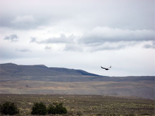 A condor sits on top of ridge. It takes off, and soars overhead. Condors have wingspans that exceed 2 meters and bodies that weight 10 kilos or more. Condors look intimidating as if they could swoop down and fly off with a small mammal in its claws. Nevertheless, they do not hunt, but rather look for dead carcasses for supper. They live in pairs, and when one dies the mate stays close by until it also dies.
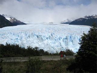 From Torres del Paine, a bus takes me across the Argentine border and north to El Calafate. El Calafate’s principal (and perhaps only) tourist attraction is the Perito Moreno Glacier. It is a spectacular jagged blue wall of ice that forms out of the merging of four glaciers that flow out of the Andes and crash into Lake Argentina. El Calafate is on the cold, windy pampa, but the glacier in the Andean foothills is easily accessible by paved road. This leads to a quickly growing tourist industry.
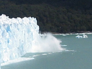 I join the pilgrimage of tourists who crowd around viewing platforms for decent views. The glacier is huge, and even though we watch it from a hillside a kilometer away it still dwarfs us. Guide books describe the glacier as both a visual and auditory experience. In reality, it is first an auditory and then maybe a visual experience. We first hear a delicious crack, like thunder or fireworks, when the glacier calves and chunks of ice splash into the lake. Most of the time, however, since sound moves so much slower than light by the time we turn in the direction of the explosion, the ice has already plummeted into the water and there is little left to see except the resulting waves.
It is impossible to watch the entire calving face at once. I watch for hours, and it requires a certain amount of dumb luck to snap a picture of the calving. Rains move in over the Andes, and so wet and cold I return to El Calafate where it is windy and cold, but at least it is sunny.
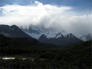 From El Calafate I head a bit farther north to Chalten, Argentina’s newest town. Chalten was founded in 1985 with the sole purpose of tourism, and the only tourist activity here is trekking into the Fitz Roy range of the Andes Mountains. A sign at the entrance to town welcomes travelers to the “National Capital of Trekking.” In the late afternoon, the clouds lift a bit and through them I catch a fleeting glimpse of the base of the Fitz Roy peak (more properly known by its aboriginal name Chalten, that gives the town its name).
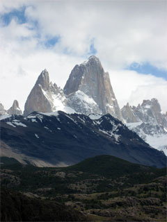 Before leaving town the next day I hike up to a viewpoint behind the visitor’s center. The timing could not have been better. On the way up the clouds started to lift over the mountains. When I reach the top, I had an almost completely clear view of the Fitz Roy peak. On my way back down, it started to cloud over again. What good luck.
This was the farthest north I would go in the Andes. I flew from El Calafate to Tierra del Fuego (Land of Fire). Ten days ago in Punta Arenas I had almost reached the southern tip of the South American continent, but here I am farther south than that. The Magellan Strait separates the island of Tierra del Fuego from the continental mainland. For many people, this place triggers imaginations of the end of the world.
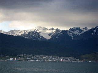 Ushuaia, on the southern coast of the island, is reputed to be the southern most city in the world. That designation, of course, depends on what one's definition of a city is. Across the Beagle Channel from Tierra del Fuego are a string of more (Chilean) islands, including Puerto Williams and other small settlements. Ushuaia is a thriving city, and seems to have lost that end of the world feeling.
 A sign at the Ushuaia port brags that from here it is only 1000 kilometers to that southern ice continent, and that the distance is much greater from South Africa, Australia, or New Zealand. Looking at a globe does confirm that relative to other southern hemisphere land masses this is quite far south. A cruise ship heads out on its way to Antarctica. For a couple thou and unlimited time, I could catch a last minute deal to the bottom of the world. Unfortunately, I have neither.
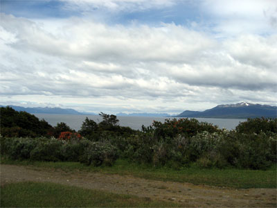
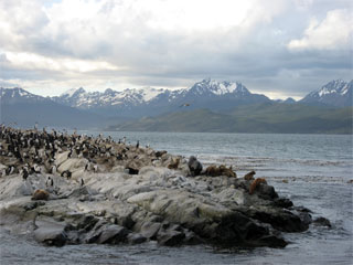
Here the Andean Mountains turn eastward after running south down the western spine of South America. Ushuaia is nestled between the Beagle Channel and the Andes. Snow capped mountains reach down to the sea. I take a boat tour on the Beagle Channel to see Magellenic penguins, King penguins, and some sort of Antarctic variety not often seen here. Cranky, sleepy sea lions and rock cormorants wander around on a rocky island. The scenery is incredibly beautiful. The sky, the light, the mountains--it's all so beautiful.
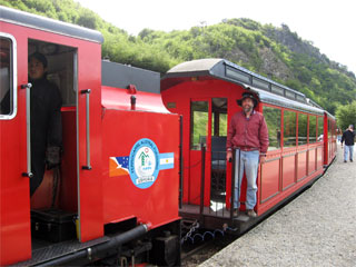 I spend a couple of days hiking in the Tierra del Fuego National Park on the edge of town. I grabbed a bus from the center of town to the Tren del Fin del Mundo (End of the World Train) that will take me to the park. As we arrived the driver cheerily called out "trencito!" (little train!). The bus was full of hikers going the park, but I was the only one to disembark. Oh boy, what was I in for?
The historic roots of the Fin del Mundo train was a narrow gauge line used at the beginning of the twentieth century when Ushuaia was founded as a penal colony. The train took convicts out with flatbed cars to harvest wood to heat the prison and generate electricity for the town. Nothing of that train or rail line remains. Instead, this is a disney version of a toy train with a steam engine brought in from South Africa and a diesel tug placed in front to pull the whole thing up a hill. Tour buses disgorge their passengers who swarm through the gift shops with their hands full of U.S. dollars and Visa cards and then push and elbow and shove to board the train. Guides on this for-profit enterprise tell dramatic stories over the PA system with swelling music under their voices. The train crawls along for its short distance to the National Park at a couple kilometers an hour.
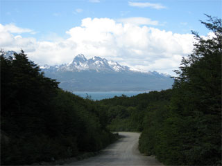 At the park, I happily jump off the train and begin to hike down a road to where I pick up a beautiful trail that parallels the Beagle Channel. The park is a bird watcher’s paradise. And there are bunnies by the hundreds (or maybe thousands)--black, cottontail, brown. They´re all here in force hopping around. The weather is beautiful. Hiking in the park is fabulous. I would have been happy to spend the entire trip camping here. This really is a special place.
I hike a trail that ends at the Chilean border. My guide book says that an unimposing marker indicates the border. Unimposing indeed. All that was there was an orange obelisk--no guards, no fence, no immigration, no nothing--not even something that says "welcome to Chile" or "thanks for visiting Argentina." The trail continues, and I wonder where it goes--what's on the other side of the border? Instead, I return to Argentina and head back to the cold Wisconsin winter.